OpenAthena™ for Android
| AppID: | com.openathena |
| Author: | mkrupczak3 |
| License: | AGPL-3.0-only |
| Donation: | |
| InRepoSince: | 2023-02-03 |
| LastRepoUpdate: | 2025-08-11 |
| LastAppUpdate: | 2025-08-11 |
| LastVersion: | 0.25.0 |
| Categories: | Navigation |
| APK source: | Github |
| Google Play: | Check if it's there |
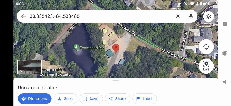
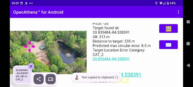
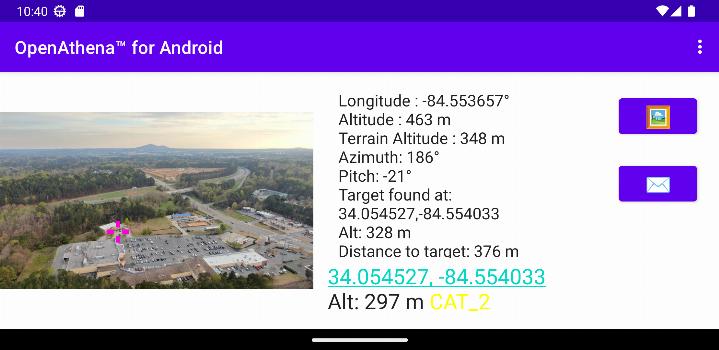
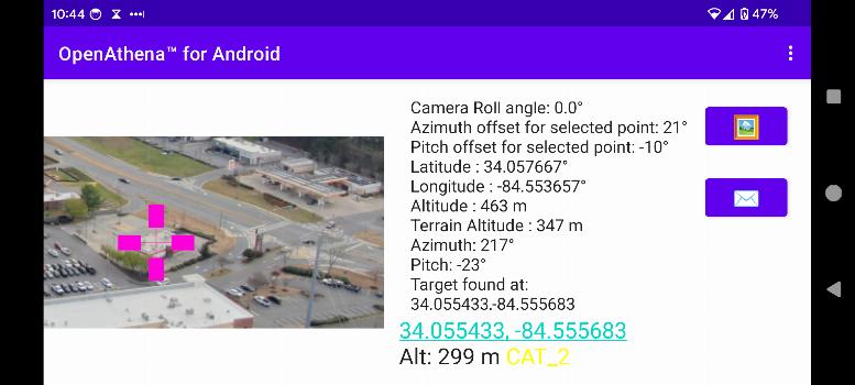
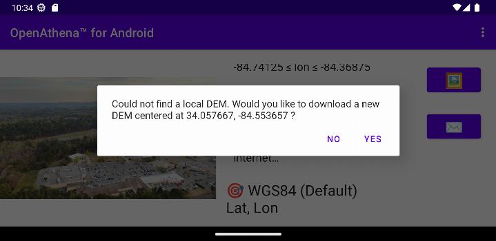
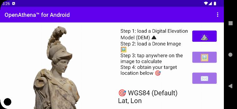
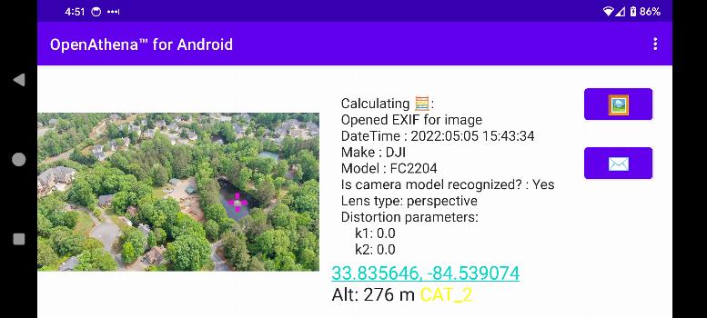
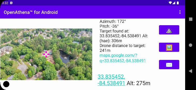
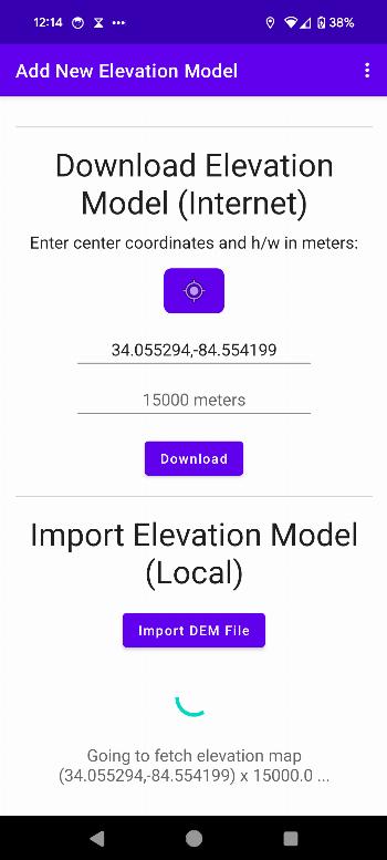
OpenAthena™ is a project that enables consumer and professional drones to identify precise locations based on their images.This is achieved by combining their sensor metadata with an offline digital elevation model to provide the instant location of the observed.
🖼️👨.💻 + 🧮 ⛰️ = 🎯📍
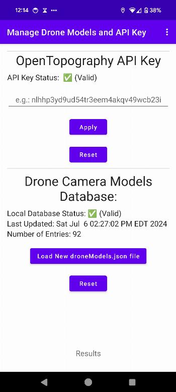
Use this link for instructions on how to obtain an OpenTopography API key required for OpenAthena.
WhatsNew:
Major release with some minor adjustments
* New and more accurate formula for target location error estimation based on slant range
* Use Copernicus GLO-30 (better accuracy) instead of SRTM for all new DEM downloads
* code cleanup
* Update app, UI, and submodules for Android 15
* update droneModels.json
* fix a crash from orientation change when re-entering app
* add easter egg for extended debug CoT mode enable/disable
* improve reliability of calculation for cropped images
 Anti-Features:
 NoSourceSince: Upstream source for this app is no longer available. Either the app went commercial, the repo was dropped, or it has moved to a location currently unknown to us. This usual means there won't be further updates unless the source reappears.NonFreeNet(this application promotes/depends a non-Free network service):
⇒ The app depends on opentopography.org, which is free to use but not libre.
Packages
Version 0.25.0 (2025-08-11) 

Android Versions:
- Target: 15.0
- MinVer: 9.0
:
:
- none
:
- none
Permissions:
- ACCESS_COARSE_LOCATION (used to determine the location)
- ACCESS_FINE_LOCATION (used to determine the location)
- ACCESS_MEDIA_LOCATION (the app’s purpose is to get the location from images)
- ACCESS_WIFI_STATE
- CHANGE_WIFI_MULTICAST_STATE
- INTERNET
- READ_EXTERNAL_STORAGE (needed up to Android 9.0 to properly access media storage)
- READ_MEDIA_IMAGES (the app’s purpose is to get the location from images)
- WRITE_EXTERNAL_STORAGE
- DYNAMIC_RECEIVER_NOT_EXPORTED_PERMISSION
Features:
- None
Malware-Check:Passed
58 Libraries detected:
- Android Support v4 (Development Framework)
The Android Support Library is not actually a single library, but rather a collection of libraries that can roughly be divided into two groups: compatibility and component libraries. For details, please see Understanding the Android Support Library.
- AndroidX Activity (Utility)
provides the base Activity subclass and the relevant hooks to build a composable structure on top.
- Android Jetpack Annotations (Utility)
library that contains the annotations for Android Jetpack.
- Arch (Utility)
helper for other arch dependencies, including JUnit test rules that can be used with LiveData.
- AppCompat (Utility)
support newer Android features on older Android versions.
- Cardview (UI Component)
AndroidX library to implement the Material Design card pattern with round corners and drop shadows.
- Android Support Library collections (Utility)
standalone efficient collections.
- Concurrent (Utility)
AndroidX library to help move tasks off the main thread with coroutines and take advantage of ListenableFuture.
- Constraint Layout Library (Utility)
library to reduce the number of nested views needed.
- Coordinatorlayout (UI Component)
AndroidX library to position top-level application widgets, such as AppBarLayout and FloatingActionButton.
- Androidx Core (Utility)
a static library that you can add to your Android application in order to use APIs that are either not available for older platform versions or utility APIs that aren't a part of the framework APIs.
- AndroidX Cursor Adapter (Utility)
static library support version of the framework's CursorAdapter.
- Android Support Library Custom View (UI Component)
a module to implement custom views. Part of the Android Support Library.
- Documentfile (UI Component)
a library to view a file document.
- Drawerlayout (UI Component)
AndroidX library to implement a Material Design drawer widget.
- Dynamicanimation (UI Component)
create smooth animations with a physics-based animation API.
- Android Emoji2 Compat (UI Component)
core library to enable emoji compatibility in Kitkat and newer devices to avoid the empty emoji characters.
- Exifinterface (Utility)
a library to read and write image file EXIF tags.
- AndroidX Fragment (UI Component)
AndroidX library to encapsulate part of the user interface or behavior into reusable components.
- Interpolator (UI Component)
AndroidX library to use animation interpolators on older platforms.
- androidx.legacy (Utility)
a static library that you can add to your Android application in order to use APIs that are either not available for older platform versions or utility APIs that aren't a part of the framework APIs.
- Lifecycle (Utility)
perform actions in response to a change in the lifecycle status of another component, such as activities and fragments.
- Loader (Utility)
library to load data for your UI that survives configuration changes.
- AndroidX Local Broadcast Manager (Utility)
an application-wide event bus and embraces layer violations in your app: any component may listen events from any other.
- Navigation (Utility)
a framework for navigating between 'destinations' within an Android application that provides a consistent API whether destinations are implemented as Fragments, Activities, or other components.
- Print (Utility)
a library to print photos, docs, and other graphics and images.
- ProfileInstaller (Utility)
AndroidX library that enables libraries to prepopulate ahead of time compilation traces to be read by ART.
- ResourceInspection (Development Aid)
AndroidX library to surface the attributes of custom views in Android Studio’s Live Layout Inspector.
- Recyclerview (Utility)
display large sets of data in your UI while minimizing memory usage.
- Android Activity Saved State (Utility)
provides the base Activity subclass and the relevant hooks to build a composable structure on top.
- Slidingpanelayout (UI Component)
AndroidX library to implement a sliding pane UI pattern.
- Startup (Utility)
AndroidX library to implement a straightforward, performant way to initialize components at app startup.
- Tracing (Utility)
AndroidX library to write trace events to the system trace buffer.
- Transition (UI Component)
animates motion in the UI with starting and ending layouts.
- Vectordrawable (UI Component)
AndroidX library to render vector graphics.
- Android Jetpack VersionedParcelable (Utility)
Provides a stable but relatively compact binary serialization format that can be passed across processes or persisted safely.
- Viewpager (UI Component)
AndroidX library to display Views or Fragments in a swipeable format.
- AndroidX Widget ViewPager2 (UI Component)
replaces AndroidX ViewPager, addressing most of its predecessor’s pain-points, including right-to-left layout support, vertical orientation, modifiable Fragment collections, etc.
- Jetpack WindowManager Library (Utility)
enables application developers to support new device form factors and multi-window environments. The library provides a common API surface for API versions 14 and later. Especially provides additional functionality on foldable devices.
- XMPCore (Utility)
Adobe’s Extensible Metadata Platform (XMP) is a file labeling technology that lets you embed metadata into files themselves during the content creation process.
- dem4j (Utility)
a java based library for reading various DEM (Digital Elevation Model) files.
- Google Material Design (Utility)
library to help with material design guidelines.
- Google Core Libraries for Java 6+ (Utility)
a set of core libraries that includes new collection types (such as multimap and multiset), immutable collections, a graph library, functional types, an in-memory cache, and APIs/utilities for concurrency, I/O, hashing, primitives, reflection, string processing, and much more.
- Error Prone (Utility)
a static analysis tool for Java that catches common programming mistakes at compile-time.
- Kotlin (Utility)
The Kotlin Programming Language
- kotlinx.coroutines (Utility)
library support for Kotlin coroutines.
- Kotlin serialization (Utility)
Kotlin cross-platform / multi-format serialization.
- Color Java (Development Aid)
a Java library providing color representation with support for hex, RBG, arithmetic RBG, HSL, and integer colors.
- Grid Java (Utility)
a Java library providing common geospatial reference system grid functionality.
- MGRS Android (Utility)
a Java library providing Military Grid Reference System functionality, a geocoordinate standard used by NATO militaries for locating points on Earth.
- Simple Features Java (Utility)
a Java library of geometry objects and utilities based upon the OGC Simple Feature Access standard.
- TIFF Java (Utility)
a Java library for reading and writing Tagged Image File Format files.
- Apache Commons (Development Framework)
an Apache project focused on all aspects of reusable Java components.
- IntelliJ IDEA (Utility)
development helper: integration for the IntelliJ IDEA IDE.
- JSpecify (Development Aid)
an artifact of fully-specified annotations to power static-analysis checks, beginning with nullness analysis.
- EGM96 (Utility)
library to compute the EGM96 offset against WGS84 altitudes reported by simple GPS receivers.
- Simple Logging Facade for Java (Utility)
abstraction for various logging frameworks (e.g. java.util.logging, logback, log4j) allowing to plug in the desired logging framework at deployment time.
- ThreeTen backport project (Utility)
Backport of functionality based on JSR-310 (Date and Time API) to Java SE 6 and 7.
- None found
Backport of functionality based on JSR-310 (Date and Time API) to Java SE 6 and 7.
- None found
Backport of functionality based on JSR-310 (Date and Time API) to Java SE 6 and 7.
Download (25 M)
Version 0.24.0 (2025-05-10) 
Android Versions:
- Target: 14.0
- MinVer: 9.0
:
:
- none
:
- none
Permissions:
- ACCESS_COARSE_LOCATION (used to determine the location)
- ACCESS_FINE_LOCATION (used to determine the location)
- ACCESS_MEDIA_LOCATION (the app’s purpose is to get the location from images)
- ACCESS_WIFI_STATE
- CHANGE_WIFI_MULTICAST_STATE
- INTERNET
- READ_EXTERNAL_STORAGE (needed up to Android 9.0 to properly access media storage)
- READ_MEDIA_IMAGES (the app’s purpose is to get the location from images)
- WRITE_EXTERNAL_STORAGE
- DYNAMIC_RECEIVER_NOT_EXPORTED_PERMISSION
Features:
- None
Malware-Check:Passed
56 Libraries detected:
- Android Support v4 (Development Framework)
The Android Support Library is not actually a single library, but rather a collection of libraries that can roughly be divided into two groups: compatibility and component libraries. For details, please see Understanding the Android Support Library.
- AndroidX Activity (Utility)
provides the base Activity subclass and the relevant hooks to build a composable structure on top.
- Android Jetpack Annotations (Utility)
library that contains the annotations for Android Jetpack.
- Arch (Utility)
helper for other arch dependencies, including JUnit test rules that can be used with LiveData.
- AppCompat (Utility)
support newer Android features on older Android versions.
- Cardview (UI Component)
AndroidX library to implement the Material Design card pattern with round corners and drop shadows.
- Android Support Library collections (Utility)
standalone efficient collections.
- Concurrent (Utility)
AndroidX library to help move tasks off the main thread with coroutines and take advantage of ListenableFuture.
- Constraint Layout Library (Utility)
library to reduce the number of nested views needed.
- Coordinatorlayout (UI Component)
AndroidX library to position top-level application widgets, such as AppBarLayout and FloatingActionButton.
- Androidx Core (Utility)
a static library that you can add to your Android application in order to use APIs that are either not available for older platform versions or utility APIs that aren't a part of the framework APIs.
- AndroidX Cursor Adapter (Utility)
static library support version of the framework's CursorAdapter.
- Android Support Library Custom View (UI Component)
a module to implement custom views. Part of the Android Support Library.
- Documentfile (UI Component)
a library to view a file document.
- Drawerlayout (UI Component)
AndroidX library to implement a Material Design drawer widget.
- Dynamicanimation (UI Component)
create smooth animations with a physics-based animation API.
- Android Emoji2 Compat (UI Component)
core library to enable emoji compatibility in Kitkat and newer devices to avoid the empty emoji characters.
- Exifinterface (Utility)
a library to read and write image file EXIF tags.
- AndroidX Fragment (UI Component)
AndroidX library to encapsulate part of the user interface or behavior into reusable components.
- Interpolator (UI Component)
AndroidX library to use animation interpolators on older platforms.
- androidx.legacy (Utility)
a static library that you can add to your Android application in order to use APIs that are either not available for older platform versions or utility APIs that aren't a part of the framework APIs.
- Lifecycle (Utility)
perform actions in response to a change in the lifecycle status of another component, such as activities and fragments.
- Loader (Utility)
library to load data for your UI that survives configuration changes.
- AndroidX Local Broadcast Manager (Utility)
an application-wide event bus and embraces layer violations in your app: any component may listen events from any other.
- Navigation (Utility)
a framework for navigating between 'destinations' within an Android application that provides a consistent API whether destinations are implemented as Fragments, Activities, or other components.
- Print (Utility)
a library to print photos, docs, and other graphics and images.
- ProfileInstaller (Utility)
AndroidX library that enables libraries to prepopulate ahead of time compilation traces to be read by ART.
- ResourceInspection (Development Aid)
AndroidX library to surface the attributes of custom views in Android Studio’s Live Layout Inspector.
- Recyclerview (Utility)
display large sets of data in your UI while minimizing memory usage.
- Android Activity Saved State (Utility)
provides the base Activity subclass and the relevant hooks to build a composable structure on top.
- Slidingpanelayout (UI Component)
AndroidX library to implement a sliding pane UI pattern.
- Startup (Utility)
AndroidX library to implement a straightforward, performant way to initialize components at app startup.
- Tracing (Utility)
AndroidX library to write trace events to the system trace buffer.
- Transition (UI Component)
animates motion in the UI with starting and ending layouts.
- Vectordrawable (UI Component)
AndroidX library to render vector graphics.
- Android Jetpack VersionedParcelable (Utility)
Provides a stable but relatively compact binary serialization format that can be passed across processes or persisted safely.
- Viewpager (UI Component)
AndroidX library to display Views or Fragments in a swipeable format.
- AndroidX Widget ViewPager2 (UI Component)
replaces AndroidX ViewPager, addressing most of its predecessor’s pain-points, including right-to-left layout support, vertical orientation, modifiable Fragment collections, etc.
- Jetpack WindowManager Library (Utility)
enables application developers to support new device form factors and multi-window environments. The library provides a common API surface for API versions 14 and later. Especially provides additional functionality on foldable devices.
- XMPCore (Utility)
Adobe’s Extensible Metadata Platform (XMP) is a file labeling technology that lets you embed metadata into files themselves during the content creation process.
- dem4j (Utility)
a java based library for reading various DEM (Digital Elevation Model) files.
- Google Material Design (Utility)
library to help with material design guidelines.
- Google Core Libraries for Java 6+ (Utility)
a set of core libraries that includes new collection types (such as multimap and multiset), immutable collections, a graph library, functional types, an in-memory cache, and APIs/utilities for concurrency, I/O, hashing, primitives, reflection, string processing, and much more.
- Error Prone (Utility)
a static analysis tool for Java that catches common programming mistakes at compile-time.
- Kotlin (Utility)
The Kotlin Programming Language
- kotlinx.coroutines (Utility)
library support for Kotlin coroutines.
- Color Java (Development Aid)
a Java library providing color representation with support for hex, RBG, arithmetic RBG, HSL, and integer colors.
- Grid Java (Utility)
a Java library providing common geospatial reference system grid functionality.
- MGRS Android (Utility)
a Java library providing Military Grid Reference System functionality, a geocoordinate standard used by NATO militaries for locating points on Earth.
- Simple Features Java (Utility)
a Java library of geometry objects and utilities based upon the OGC Simple Feature Access standard.
- TIFF Java (Utility)
a Java library for reading and writing Tagged Image File Format files.
- Apache Commons (Development Framework)
an Apache project focused on all aspects of reusable Java components.
- IntelliJ IDEA (Utility)
development helper: integration for the IntelliJ IDEA IDE.
- EGM96 (Utility)
library to compute the EGM96 offset against WGS84 altitudes reported by simple GPS receivers.
- Simple Logging Facade for Java (Utility)
abstraction for various logging frameworks (e.g. java.util.logging, logback, log4j) allowing to plug in the desired logging framework at deployment time.
- ThreeTen backport project (Utility)
Backport of functionality based on JSR-310 (Date and Time API) to Java SE 6 and 7.
- None found
Backport of functionality based on JSR-310 (Date and Time API) to Java SE 6 and 7.
- None found
Backport of functionality based on JSR-310 (Date and Time API) to Java SE 6 and 7.
Download (23.4 M)